Aerialphoto Service Launches "3D Point Cloud Surveying Service" for Drone Simulators Started "3D Point Cloud Surveying Service" for NDD's drone simulator.
空撮サービス株式会社
Aerialphoto Service Co., Ltd.(headquartered in Minato-ku, Tokyo; Tetsuo Yamamoto, President; hereinafter "the Company") will launch a 3D point cloud surveying service on July 23, 2025 (Wednesday) for the drone operation simulator developed by NDD Corporation (Hideki Tsukada, President; hereinafter "NDD").
An outline of this service will be exhibited at Maintenance Resilience TOKYO 2025 (Booth NO. 6-V22), which will be held from July 23 (Wed.) to July 25 (Fri.), 2025.
■Providing 3D point cloud models for a drone piloting simulator developed by NDD
Infrastructure facilities such as bridges and dams built during the high-growth period are aging, and combined with abnormal weather conditions, inspection work to ensure safety is increasing, but there is also a shortage of human resources for inspection workers. However, many infrastructure facilities are located in harsh environments in mountainous areas, and drone pilots are required to have more advanced skills due to special shapes and poor GNSS accuracy. NDD has developed an application (SkyAce for Inspection) that enables such pilots to simulate drone operations in a more realistic 3D space. The Aerialphoto Service will provide users of this application with an inexpensive 3D point cloud model of the actual equipment to be addressed. This will enable users of SkyAce for Inspection to confirm the inspection operation image of the equipment to be inspected before the actual inspection work, shortening the actual work time and enabling them to prepare for safety measures.
An overview of this service will be exhibited at Maintenance Resilience TOKYO 2025 (Booth NO. 6-V22), which will be held from July 23 (Wed.) to July 25 (Fri.), 2025.
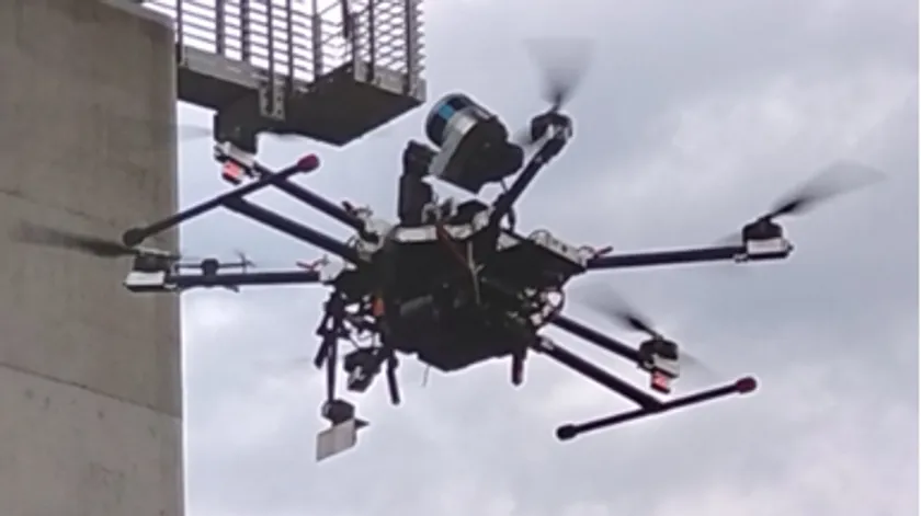
Drone for 3D point cloud surveying
What is Aerialphoto Service?
Amidst the frequent occurrence of large-scale disasters, infrastructure facilities built during the high-growth period are aging and there is a concurrent shortage of inspection personnel due to the declining birthrate and aging population. The inspection of infrastructure facilities involves a lot of dangerous work in a harsh environment, and this is one of the fields where the use of drones is most needed. Aerialphoto Service is based on ArduPilot, a mainstream open-source flight system, and by developing our own software to link with sensors such as LiDAR and total stations (TS) used in surveying sites, and gimbals for mounting commercial cameras,so we are able to develop drones that can automatically fly and inspect steel towers, dams, bridges,and provide those drone systems. It was established in January 2015 as an affiliate of Fordy Networks Corporation, which provides original embedded Java applications for multifunction devices.
About SkyAce for Inspection
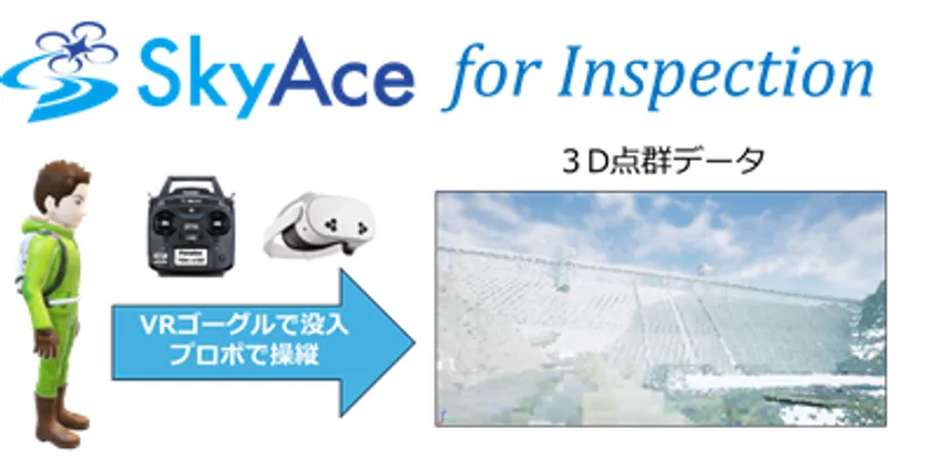
Image of SkyAce for Inspection
SkyAce for Inspection is a series of drone piloting simulators by NDD. The simulator allows users to pilot a drone in a 3D space using an actual radio system, and enables efficient drone training without the risks (accidents, breakdowns, bad weather, etc.) that are assumed in training with actual drones.
SkyAce for Inspection allows the operator to fly through a 3D model of the facility to be inspected (dam, bridge, etc.) using VR goggles and multiple PC monitors. SkyAce for Inspection aims to provide training that is in line with the flow of actual inspection work.
■Company Profile
Aerialphoto Service Co., Ltd.
Representative: Tetsuo Yamamoto, President and Representative Director
Location: Isarako Nibankan 4F, 2-16-53 Takanawa, Minato-ku, Tokyo 108-0074, Japan
Image

Logo Image
- Category:
- Technology & Development